| ||||||||||||||||||||||
| copyrights 2011 |
Friday, 27 February 2015


 There are plenty of cells and tunnels inside the fort and most of them are secret ones and yet to be found. Some of the cells/rooms were used as godowns. We decided to explore one such hidden cell in the south-eastern part of the fort. Just near the staircase we enter a small room in the fortification where we find a staircase leading to an open door in the upper wall of the room. After passing thru the door, we again climb a small spiral stairway, we reach a dark square hole/passage in the wall. This section will be about 2ft/2ft in size and one has to squeeze thru to pass by. After careful scrutiny of this passage, we climb up and reach the end of the passage which is wide at the end. There is an empty room at this place. On the right, there is a staircase, which takes us up to the south-eastern bastion. A good exploration-cum-adventure.
 The ramparts connect both these bastions to the rest of the fort walls. These bastions are completely broken and one can view the ground floor of the same. This area faces the sea which is about ½ km away. In the olden days the sea water used to reach right upto the fort walls and incase of bad weather, boats heading towards the north used to anchor on the trees which are on the western side of the fort walls. However now, the water has receded far away making the area marshy. Behind the fort one can see a small bund which brings in the sea water to irrigate the village fields. There is a small well inside the fort, which is now covered with creepers and bushes.
 woods towards the north side of the beach. We refer toP.K.Ghanekar's book and find a note on ‘Madla Bhruj'. We walk for about 15min thru the woods and reach this fortification. The only entrance to this fortification is thru the eastern side which is somewhat buried in the sand. On has to end and get inside. The second entrance is also in the same state after which we reach a balekilla kind of structure facing the sea shore on the west. The height of the fortification on this side is about 15-20ft (this would be the actual height of the bhurj). This small fort has 4 bastions.
 The only way to enter is to climb up the fort walls about 20ft long. We do so by making use of the niches in the wall, and enter the small square openings in the bastion walls. There are 8 such small openings/entrances which can be used to access the fort during both high & low tides. At the western end of the of the fort we see a wall that separates a small part of the fort. The door used to exist but now in place one finds only a broken arch. On the left we can find a fresh water tank. The broken arch leads us into the balekilla which is like a huge watch tower 2 storeyed, but completely open and ruined. The walls on the left and right run narrow from east to west. They have huge windows on both the levels. Ruzbeh tries his stunt and climbs onto one of the upper windows. After taking a few photos, we descend back the fort walls and then reach Kelve village which is about 10min walk away from the fort.
 2 bastions. The one on the left is small and the western walls falls into somebody's private property. The bastion on the right is a huge one with 2 entrances. Both the entrances have wooden frames. There is a small church installed into the wall near the doors with the statues ofMother Mary clad in a sari holding baby Jesus. This church has been constructed in year 2002. We could not enter the fort cause of wild undergrowth inside. We return back to the road and move on keeping the bastion wall on the left. We reach an intersection, were the road to the left leads into Arnala village, on the right the road goes across the newly constructed bridge to Danda village. We move towards the left following the bastion wall which at the intersection falls into the customs office compound. The wall breaks of here. This area has been encroached by the village folk.
 Gadeshwar Prasanna”. However, we can find many other deities also inside such as Saibaba, Ganesh, Ekavira Devi, a small temple next to it dedicated to Lord Kartikeya (brother of lord Ganpati) and a yagna kund. This was quite unusual as one does not find as many temples of lord Kartikeya in Maharashtra as he is popular in the south. By the time we reached the temple there
 was not a soul there other than us. The atmosphere around is eternal bliss and we enjoyed spending some time there. We then moved on and reached the eastern main entrance with two huge bastions. The entrance is broken without any doors. We go inside towards the right and then turn left, climb up thru the bushes, pass between two broken fortifications of the balekilla and reach the inner area of the balekilla. Here we find a water tank well maintained and the water is potable. We now traverse the entire balekilla with extreme care as such areas are usually the home to several reptiles mainly snakes. This fort is also covered by a lot of cashew nut trees, though lesser than the earlier days when this region use to produce a lot of cashew nuts.
 We take the 5:30pm ferry across the creek and decide to make a quick tour of the fort to reach back in time for the last boat departing from the island at 7pm . The boat journey lasts for about 10min. We speedily walk towards the village and then reach the northern gate of the fort which is the main entrance. There are some inscriptions written here on the arch indicating that the fort was renovated by the Peshwa Bajirao 1. We move inside the entrance and check out the maha darwaja with huge dome and high circular ceilings. We turn left and enter the fort.
 huge and one can find staircases leading to hidden cellars in all the bastions. The middle bastion on the western wall is the biggest and has a hidden route from the top of the bastion to the western doorway. There is a Trimbakeshwar, a Bhavani Mata Temple and a Masjid inside the fort. Opposite the Trimbakeshwar temple is an octagonal shaped stepped well called as ‘Pushkarni'. At the eastern end of the fort we find a small temple like structure which houses the ‘padukas' of Swami Nityananda. There are two fresh water wells inside the fort, which provide
  drinking water to the villagers. From the southeastern bastion, we can spot a lone bastion at the south end of the island. This bastion is called as ‘Tehelni bastion' We traverse the entire fort by walking on the fort ramparts, descend from the northern side and walk across to the southern exit from where we reach the lone bastion at the southern end of the island. This bastion entrance is now buried in sand therefore one has to take hold of the strong roots of the trees which are growing inside the bastion (on the eastern side) and climb up the wall and enter thru the bastion windows. There is nothing inside except for a lot of sand and rubble. Ruzbeh again does a stunt and climbs up the bastion. Thanks to his height he is able to do so. I do not attempt purely due to time factor as we are already getting late. Ruzbeh descends quickly and we sprint our way back to the boat point from where we take the 6:30pm ferry and reach Arnala. Walking thru the village we reach the town bus stand from where we take a bus to Virar. We take the 8pm train and reach home by 9:30pm , thus bringing to an end another major expedition.
Sunday, 22 February 2015
Wednesday, June 22, 2011
[PART 11]Dedicated to Mumbai[Bombay]
PART 1A-http://oldphotosbombay.blogspot.com/2011/09/1a-bombaymumbai-taxi-1850-to-2001-also_3982.html
[PART-2]http://oldphotosbombay.blogspot.com/2011/04/glimpses-of-old-bombay-and-western.html
[PART-3]http://oldphotosbombay.blogspot.com/2011/04/glimpses-of-old-bombay-and-western_02.html
[PART-4]http://oldphotosbombay.blogspot.com/2011/04/4glimpses-of-old-bombay-and-western.html
[PART-5]http://oldphotosbombay.blogspot.com/2011/04/dedicated-to-first-city-mumbai-bombay.html
[PART-6]http://oldphotosbombay.blogspot.com/2011/04/6.html
[PART-7]http://oldphotosbombay.blogspot.com/2011/04/6-glimpses-of-old-bombay-and-western.html
[PART-8]http://oldphotosbombay.blogspot.com/2011/04/7.html
[PART-9]http://oldphotosbombay.blogspot.com/2011/04/first-anglo-maratha-war-was-first-of.html
[part-10] http://oldphotosbombay.blogspot.com/2011/06/bombay-history-of-cinema-1896-and.html
[PART12] MAPS OF BOMBAY 1843 TO 1954http://oldphotosbombay.blogspot.com/2011/06/maps-of-mumbai-bombay.html
"Indian Modes of Irrigation"1874


*"An Elephant Auction 1875
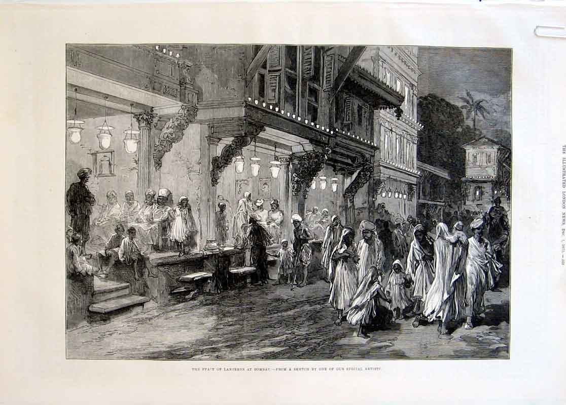
 "The Feast of Lanterns at Bombay"*, 1875
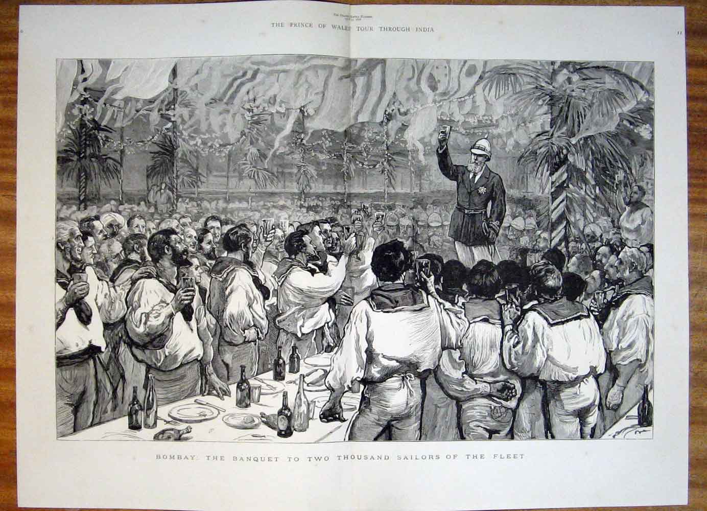
"Bombay: The Banquet to Two Thousand Sailors of the Fleet"*, 1876
 An Unwelcome Visitor-- A Frequent Incident of Anglo-Indian Life"*, from The Graphic, 1879
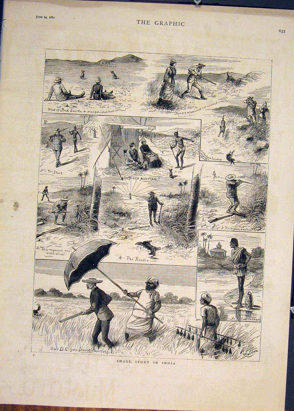
*"Small Sport in India"*, from The Graphic, 1882


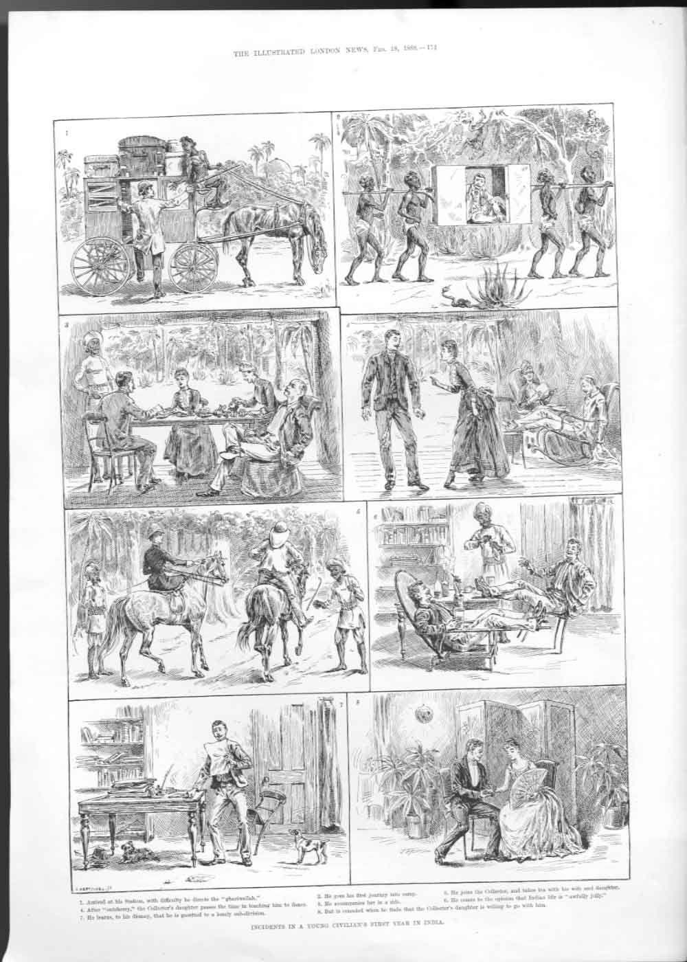
"Young Civilian's First Year in India"*, 1888
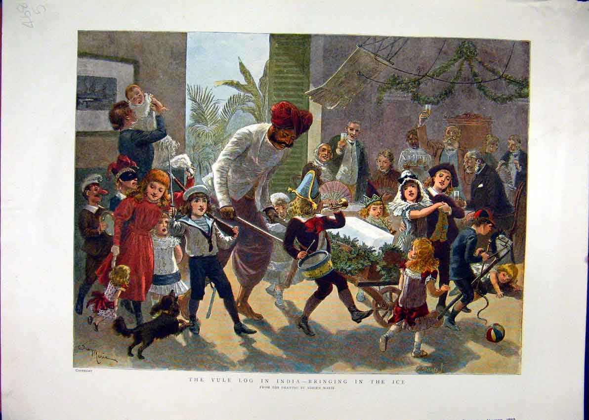
 The Yule Log in India--Bringing in the Ice"*, from The Graphic, 1889
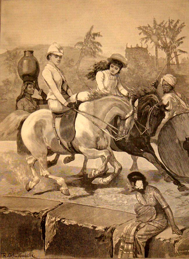
 *"The Morning Ride"*, 1891
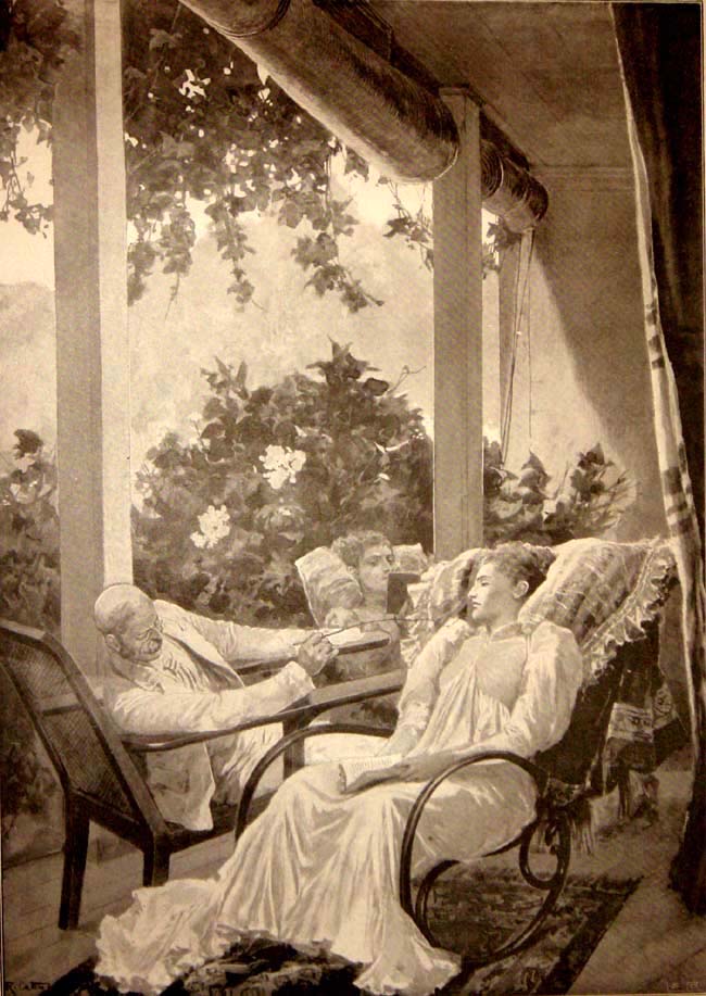
  Dolce Far Niente: Life in an Indian Bungalow"*, 1896
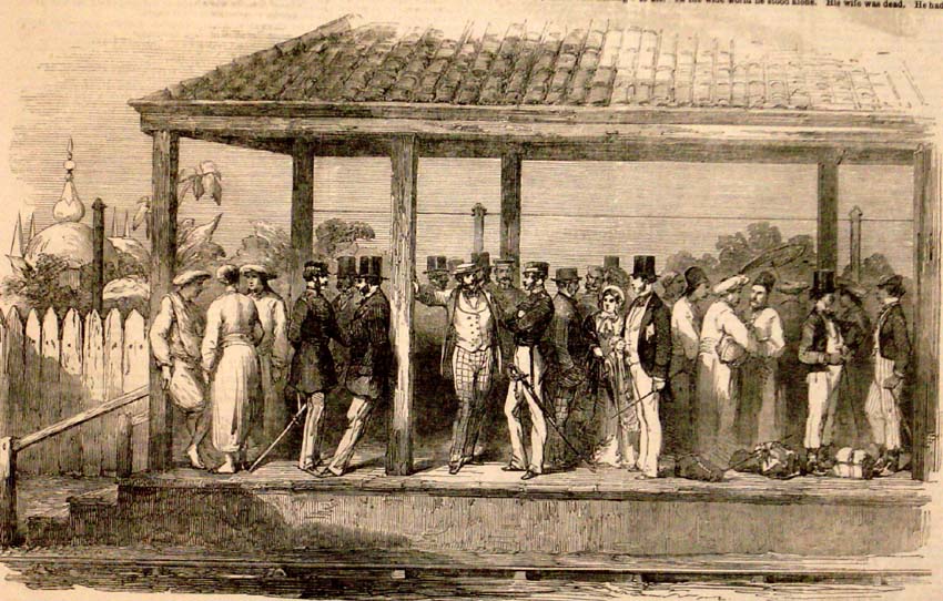
  *"An Indian Railway Station"*, 1854


Pen and ink drawing of Sewri Fort in Bombay looking across to Trombay Island by William Miller (1795-1836) in 1828.The image is inscribed: 'Suree from below the Band hill. Bandalah. W.M. December 1828'.
Sewri Fort was located on the eastern shore of Parel Island and constructed in 1770. Parel Island, along with Trombay, was one of seven that originally made up the area of Bombay. The artist, William Miller, had a house at Parel. It was located at Vadalla between the towns of Sewri and Matunga. In this view an officer is shown sketching on the left. This figure is probably a self portrait of the artist.

Photograph of a street in the Fort area of Bombay (Mumbai), Maharashtra, by an unknown photographer, from an album of 40 prints taken in the 1860s. Bombay, one of the key cities of India, is a major port, busy manufacturing centre and capital of Maharashtra. During British rule, it was the administrative capital of the Bombay Presidency. It extends over a peninsula jutting into the Arabian Sea on the west coast of India. Originally a collection of fishing villages of the Koli community built on seven islands, Bombay was by the 14th century controlled by the Gujarat Sultanate who ceded it to the Portuguese in the 16th century. In 1661 it was part of the dowry brought to Charles II of England when he married the Portuguese princess Catherine of Braganza. The British built up fortifications around Bombay harbour in the 17th century around the original Portuguese settlement. In the 1760s the fortifications were enhanced as the British were engaged in war with France in both Europe and India. By the 19th century the British had established control over India and the fort walls were torn down and the area converted into the central district of Bombay city.
1883--"THE LUKHMIDAS KHIMJI KAPAD BAZAR "-NEW CLOTH MARKET--BOMBAY--[UPPER RIGHT PICTURE]

BOMBAY-1867--SCREW STEAMER 'EUPHRATES' CARRYING BRITISH TROOPS TO INDIA

1866--LAUNCH OF TROOP SHIP -JUMNA-

BOMBAY-1870-VICTORIA RAILWAY TERMINUS---5 PHOTOS OF SAME BUILDING ---[SHOWS HORSE DRAWN TRAM BUSES FOR PASSENGERS]An albumen print, c.1870;
A magnificent building, completed in 1888, the Victoria Terminus was named after the then Queen Empress on Jubilee Day, 1887. Construction started in 1878 based on a design by F. W. Stevens, and took 10 years to complete. The cost of construction was Rs. 16.14 lakhs (Rs. 1.614 million). The railway station was opened to the public on New Year's Day, 1882. It is now the starting point of the Central Railways.
Built in the Victorian Gothic Revival style, based on Italian Gothic models, the complicated ground plan of the building is counterpointed by marvellous filigrees, carvings and arches. The south-western part of the building is topped by a dome holding up a statue of Progress. It is an early example of a uniquely Bombay style of architecture which emerged when British architects worked with Indian craftsmen to include Indian architectural tradition and idioms.
When the building was first used it held not only railway functionaries such as the accounts, chief engineer and traffic manager but also other municipal offices such as the superintendent of the police. Curiously, railway tickets were also printed in the same building. The number of people working here rose for almost a hundred years. In the 1980's the Railways began to lighten the load on the structure. It presently holds over 700 employees of the Central Railway.

another view, c.1880's*OF SAME BUILDING:-

A collotype print, c.1900, by Clifton & Co.:-

*Victoria Terminus and its streetscape, 1908*

A modern visitor's photo

Built in the Victorian Gothic Revival style, based on Italian Gothic models, the complicated ground plan of the building is counterpointed by marvellous filigrees, carvings and arches. The south-western part of the building is topped by a dome holding up a statue of Progress. It is an early example of a uniquely Bombay style of architecture which emerged when British architects worked with Indian craftsmen to include Indian architectural tradition and idioms.
When the building was first used it held not only railway functionaries such as the accounts, chief engineer and traffic manager but also other municipal offices such as the superintendent of the police. Curiously, railway tickets were also printed in the same building. The number of people working here rose for almost a hundred years. In the 1980's the Railways began to lighten the load on the structure. It presently holds over 700 employees of the Central Railway.
another view, c.1880's*OF SAME BUILDING:-
A collotype print, c.1900, by Clifton & Co.:-
*Victoria Terminus and its streetscape, 1908*
A modern visitor's photo
The Victoria Terminus was renamed Chhatrapati Sivaji Terminus on March 4, 1996. In September 1999 pedestrian access to the suburban railway terminus was moved underground. The subway was built at the incredible cost of Rs. 15 crores (Rs. 150 million).
This building has long been on the urban heritage list and a protected monument. It was put on theUNESCO World Heritage List on July 2, 2004. It is the first functional administrative building to be put on this list.
1858-BOMBAY--Residence of Jejeebhoy[Sir Jamsetjee Jejeebhoy, 1st Baronet (15 July 1783 – 14 April 1859)]

BOMBAY-1675-PEOPLE AND BUSINESS
In 1661, the islands of Bombay passed to the British Crown, when Charles II married Catherine of Braganza. However, the Portuguese garrison in Bassein refused to part with the islands of Salsette, Parel, Worli and Mazagaon.
British soldiers captured these islands only in 1665, and a treaty was signed in the manor house on the island of Bombay.
Proceeding roughly south to north, the seven islands ceded by the Portuguese to the British were
|
This list does not exhaust all the islands that have merged into the modern city of Bombay. In particular,Salsette, the large northern island which remained under Portuguese control till 1739, is not counted among these seven.
British soldiers captured these islands only in 1665, and a treaty was signed in the manor house on the island of Bombay.
The British East India Company received it from the crown in 1668 for the sum of 10 pounds a year, payable every September 30. Sir George Oxenden, then President of the factory in Surat, became the first Governor of Bombay. The Company immediately set about the task of opening up the islands by constructing a quay and warehouses. A customs house was also built. Fortifications were made around the manor house, now renamed Bombay Castle. A Judge-Advocate was appointed for the purpose of civil administration. Sir George died in 1669.
Gerald Aungier was appointed the President of the Surat factory and Governor of Bombay in 1672, and remained at this post till 1675. He offered various inducement to skilled workers and traders to set up business in the new township. As a result, a large number of Parsis, Armenian, Bohras, Jews, Gujarati banias from Surat and Diu and Brahmins from Salsette came to Bombay. The population of Bombay was estimated to have risen from 10,000 in 1661 to 60,000 in 1675.
The first four governors held Bombay for the Crown:-
The first four governors held Bombay for the Crown:-
| 1 | Abraham Shipman | 19 March 1662 | October 1664 | 2 | |
| 2 | Humphrey Cooke | February 1665 | 5 November 1666 | 1 | Acting |
| 3 | Gervase Lucas | 5 November 1666 | 21 May 1667 | 1 | |
| 4 | Henry Gary | 22 May 1667 | 23 September 1668 | 1 | Acting |
| 1 | George Oxeden | 23 September 1668 | 14 July 1669 | 1 | ||
| 2 | Matthew Gray | 14 July 1669 | 7 June 1672 | 3 | Acting | |
| 3 | Gerald Aungier | 7 June 1672 | 30 June 1677 | 5 | ||
| 4 | Henry Oxenden | 30 June 1677 | 27 October 1681 | 4 | ||
| 5 | John Child | 27 October 1681 | 27 December 1683 | 2 | ||
| 6 | Richard Keigwin | 27 December 1683 | 19 November 1684 | 1 | Acting | |
| 7 | Charles Zinzan | 19 November 1684 | 1685 | 1 | Acting | |
| 8 | John Wyborne | 1685 | 2 May 1687 | 2 | Acting | |
| 9 | John Child | 2 May 1687 | 4 Feb 1690 | 3 | ||
| 10 | Bartholomew Harris | 4 February 1690 | 10 May 1694 | 4 | ||
| 11 | Daniel Annesley | 10 May 1694 | 17 May 1694 | Acting | ||
| 12 | John Gayer | 17 May 1694 | November 1704 | 10 |
Gerald Aungier established the first mint in Bombay. In 1670 the Parsi businessman Bhimjee Parikh imported the first printing press into Bombay.

Aungier planned extensive fortifications from Dongri in the north to Mendham's Point (near present day Lion Gate) in the south. However, these walls were only built in the beginning of the 18th century. The harbour was also developed, with space for the berthing of 20 ships. In 1686, the Company shifted its main holdings from Surat to Bombay.
Aungier planned extensive fortifications from Dongri in the north to Mendham's Point (near present day Lion Gate) in the south. However, these walls were only built in the beginning of the 18th century. The harbour was also developed, with space for the berthing of 20 ships. In 1686, the Company shifted its main holdings from Surat to Bombay.
During the Portuguese occupation, Bombay exported only coir and coconuts. With the coming of many Indian and British merchants, Bombay's trade developed. Soon it was trading in salt, rice, ivory, cloth, lead and sword blades with many Indian ports as well as with Mecca and Basra.
BOMBAY -The Parsis
GUJARAT ...

Some Zoroastrian Persians migrated to India after the fall of the Sassanian Empire, and gave rise to the modern Indian Parsi community. According to a chronicle written in the 17th century, the Kissah-i-Sanjan, the Parsis first came to India in the 8th century. They landed in Diu, and were later given refuge in Sanjan (Gujarat) by the local king, Jadi Rana. Five years after this they built the first fire temple, Atash Behram, to shelter the holy fire rescued from Iran.
Over the years this community accultured to the new land. Gujarati became the native language of the community and the sari the garment of the women. However the Parsis preserved their separate cultural and religious identity.
Towards the end of the 10th century, the Parsis began to settle in other parts of Gujarat. This gave rise to difficulties in defining the limits of priestly jurisdiction, which were resolved in 1290 AD by the establishment of five panthaks or districts--
Sanjan,

The main cave at Bahrot

The Dakhma Mound at Sanjan

Structures and Ringwells at Sanjan

The Bahrot Fort wall
Nausari,

Godareh-Ankleswar, Broach and Cambay.
Late in the 15th century Sanjan was attacked by a Muslim army, probably a war of conquest by the sixth Sultan of Gujarat. The Parsis supported the local Hindu king with 1400 men, and were annihilated. The survivors fled with the holy fire, which was installed in Nausari in 1516. Later, due to disputes between priests, it was transferred and came to its present location in
Udvada in 1742.


BHUJ AGIARY
... BOMBAY

Parparsisi Fire Temple, Bombay.
Parsi fire temple Bombay
From the 16th century, Surat became a major centre of trade, and more and more Parsis migrated to this town. The newly arrived European traders preferred to conduct business through this community, since their status as a minority gave them the necessary flexibility in their new role as brokers. The first record of a Parsi, Dorabji Nanabhai,
settling in Bombay dates from 1640.
After 1661, when Bombay passed to the British, there was a concerted effort to bring artisans and traders to settle in the new town. Aungier wrote a letter to the Factor in Surat on November 21, 1647
to invite as many weavers as possible, ... whereinto you will promise them such priviledges, immunities, and exemptions from publique duties as they shall reasonably desire from you..
{PLEASE NOTE:-PEOPLE WERE ASKED TO COME AND SETTLE IN BOMBAY COMPARED TO TODAYS NARROW POLITICS OF ATTACKING SO CALLED OUTSIDERS}
A large part of the Parsi migrants to Bombay in these years was constituted of weavers and other artisans. In 1673, the British handed over a piece of land in Malabar Hill to the Parsi community for the establishment of their first Dakhma,
Tower of Silence.

In 1735 Lowjee Nusserwanji, a master shipbuilder, was granted land in Bombay by the East India Company. He took the name of his trade, Wadia, and moved into the developing town
It has been said that it was not the British merchant but the Parsi shipbuilder who was the real creator of Bombay. In 1736, East India Company officials, very impressed with the work of a young Parsi foreman in their Surat dockyard, invited him to Bombay, with ten of his carpenters, to build the Bombay shipyard. Lowji Nusserwanji Wadia came to Bombay and put in fifty years of service, at a salary of forty rupees a month, handing down his skills to his sons and grandsons. For many decades, it was the success of the shipyards alone that persuaded the East India Company to keep this otherwise expensive settlement going.
The Wadias made ships of Malabar teak for an international clientele. Their Bombay Frigates were ordered by the British Admiralty and used in the Battle of Trafalgar. One of their ships sailed the world for years with the following message carved on her kelson by the chief shipwright, Jamshetji Wadia, "This ship was built by a d----d Black Fellow AD 1800." The Wadias weren't the only stars in the Parsi firmament. Parsi entrepreneurs began springing up in every direction, attempting new professions and being enormously successful. It is said that the Bombay of those days was a level playing field where there were fortunes to be made, caste, colour, creed, no bar; though in the colour-conscious world of British India, it could not have hurt to be light-skinned like some Parsis.}
Incidentally, the Wadias built the ship Minden, on board which Francis Scott Key composed the US national anthem "Star Spangled Banner".
In 1780, 9.2% of the population of Bombay were Parsis. A first wave of migration followed a famine in Gujarat in 1790. By 1812 the number of Parsis in Bombay had quadrupled. In 1837, a second large wave of migrations to Bombay followed a huge fire in Surat. Today, more than 70% of all Parsis live in Bombay.
he Parsis are intimately connected with the history of Bombay. The cotton boom was largely fuelled by Parsi entrepreneurs. The oldest newspaper in Bombay, "Bombay Samachar", was run by Parsis.Congress stalwarts like
Dadabhai Naoroji,
Dadabhai Naoroji,

To educate the British public and to fight for Indian rights, in 1892 he stood for elections to the British House of Commons as a liberal from Central Finsbury. He won by three votes and his constituents nicknamed him 'Mr Narrow Majority'. He was the first Indian to beat the British at their own game. The conservative press did their best to stir up racial prejudice against him.
Central Finsbury should be ashamed of itself at having publicly confessed that there was not in the whole of the Division an Englishman, a Scotsman, a Welshman, or an Irishman as worthy of their votes as this fire-worshipper from BombaY
Central Finsbury should be ashamed of itself at having publicly confessed that there was not in the whole of the Division an Englishman, a Scotsman, a Welshman, or an Irishman as worthy of their votes as this fire-worshipper from BombaY
Pherozeshah Mehta

Sir Pherozeshah Mehta, KCIE (August 4, 1845 - November 5, 1915) was an Parsi Indian political leader, activist, and a leading lawyer, who was knighted by then British Government in India for his service to the law. His political ideology was, as was the case with most of the Indian leaders of his time, moderate and was hence not directly opposed to the crown's sovereignty but only demanded more autonomy for Indians to self-rule.
He became the Municipal commissioner of Bombay Municipality in 1873 and its President four times - 1884, 1885, 1905 and 1911.

Madame Bhikaiji Cama (1861-1936) our radical firebrand, was exiled from India and Britain and lived in France. Bhikaiji was a tireless propagandist for Indian Independence. Russian comrades used to call her India's Joan of Arc. Lenin reportedly invited her to reside in Russia but she did not accept the invitation.44
In 1907, she addressed an audience of 1,000 Germans at the Stuttgart Conference. After her impassioned speech she unfurled a flag, a tricolour, which became, with some changes, India's national flag forty years later. As her activities grew more radical the British requested the French to extradite her. The French refused. In 1936, alone and seriously ill, wishing to die in her own country she petitioned the British government to be allowed to return home. Her request was granted, provided she sign what she had refused to all her life; a statement promising she would take no part in politics. She returned to Bombay and after an illness of eight months, died lonely, forgotten and unsung in the Parsi General Hospital.
ame Bhikaiji Cama (1861-1936) our radical firebrand, was exiled from India and Britain and lived in France. Bhikaiji was a tireless propagandist for Indian Independence. Russian comrades used to call her India's Joan of Arc. Lenin reportedly invited her to reside in Russia but she did not accept the invitation.44
In 1907, she addressed an audience of 1,000 Germans at the Stuttgart Conference. After her impassioned speech she unfurled a flag, a tricolour, which became, with some changes, India's national flag forty years later. As her activities grew more radical the British requested the French to extradite her. The French refused. In 1936, alone and seriously ill, wishing to die in her own country she petitioned the British government to be allowed to return home. Her request was granted, provided she sign what she had refused to all her life; a statement promising she would take no part in politics. She returned to Bombay and after an illness of eight months, died lonely, forgotten and unsung in the Parsi General Hospital.
Dinshaw Wacha

Sir Dinshaw Edulji Wacha (1844-1936) was a Parsi Indian politician from Bombay. He was one of the founders of the Indian National Congress, and its President in 1901.
He was President of the Indian Merchants' Chamber in 1915.
TATA

Even the physical shape of Bombay was determined by donations to build causeways, roads and buildings by members of theJeejeebhoy his first voyage to China (1800)to trade in cotton and opium.


Sir JJ as he was
known , was one of India's greatest philanthropists
known , was one of India's greatest philanthropists
Sketch of Jejeebhoy, 1857
An essentially self-made man, having experienced the miseries of poverty in early life, Jejeebhoy developed great sympathy for his poorer countrymen, and in his later life was occupied with alleviating human distress in all its forms. Parsi and Christian, Hindu and Muslim, were alike the objects of his beneficence. Hospitals, schools, homes of charity and pension funds throughout India (particularly in Mumbai,
Jejeebhoy donated to at least 126 notable public charities, including the Sir Jamsetjee Jeejebhoy School of Art, the Sir J. J. College of Architecture, the Sir J.J. Institute of Applied Art and the Seth R.J.J. High School. He also endowed charities dedicated to helping his fellow Parsis and created the "Sir Jamsetjee Jeejebhoy Parsi Benevolent Fund".
Mahim Causeway: the British Government had refused to build a causeway to connect the island of Salsette to Mumbai. Jejeebhoy's wife Avabai Jamsetjee Jeejeebhoy spent 1,55,800 rupees to finance its construction, naming it after his wife Avabai. The work began in the year 1841 and is believed to have been completed 4 years late
The Illustrated London News print of Jejeebhoy's residence, 1858

The fifth Baronet, Sir Jamsetjee Jejeebhoy at home. The first Baronet, Sir JJ as he was
known , was one of India's greatest philanthropists. Schools, colleges, hospitals, still
bear his name. Bombay 1984.
known , was one of India's greatest philanthropists. Schools, colleges, hospitals, still
bear his name. Bombay 1984.
and Readymoney families.

Sir Cowasji Jehangir Readymoney, CSI (1812–1878)

Fountain erected by Cowasji Jehangir Readymoney in Regent's Park, London
SIR COWASJI JEHANGIR READYMONEY (1812-1878), "the Peabody of Bombay." Readymoney (first to loan money to the British).Early in the 18th century three Parsee brothers moved from Nowsari, near Surat, in Gujarat, to Bombay, and became the pioneers of a lucrative trade with China. They gained the sobriquet of "Readymoney," which they adopted as a surname. Only Hirji Jewanji Readymoney left issue, two daughters, the elder of whom married a Banaji, and the younger a Dady Sett. The son of the former, Jehangir Hirji, married Mirbae, the daughter of the latter, and was made the heir not only of his grandfather, but of his two granduncles. The younger of their two sons was Cowasji Jehangir. His only English education was at the then well-known school kept by Serjeant Sykes in the Fort of Bombay. At the age of 15 he entered the firm of Duncan, Gibb & Co. as "godown keeper," or warehouse clerk. In 1837 he was promoted to the responsible and lucrative appointment of "guarantee broker" to two of the leading European firms of Bombay. In 1846 he was able to begin trading on his own account. He was made a J.P. for the town and island of Bombay, and a member of the board of conservancy; and in 1866 was appointed a commissioner of income tax, his tactful management being largely responsible for the fact that this tax, then new to Bombay and unpopular, was levied with unexpected financial success. He was made C.S.I. in 1871; and in 1872 he was created a Knight Bachelor of the United Kingdom, and his statue, by T. Woolner, R. A., was erected in the town hall. His donations to the institutions of Bombay amounted to close on £ 200,000. His health broke down in 1871, and he died in 1878, being succeeded by his son, Sir J. Cowasji Jehangir [Readymoney],
who was created a Knight Bachelor in 1895, and a Baronet in 1908.
who was created a Knight Bachelor in 1895, and a Baronet in 1908.
1887 Queen'S Jubilee Bombay

1874-CROSSING RIVER-INDIANS AND ENGLISH MAN WITH FAMILY - HORSE POWER

Bombay 1881-VIEW FROM MALABAR HILL?was possibly taken looking east from Cumbala Hill.


Bombay, one of the key cities of India, is a major port on the west coast of India, a busy manufacturing centre and the capital of Maharashtra. Originally a collection of fishing villages of the Koli community built on seven islands, land reclamation formed a peninsula jutting into the Arabian Sea, over which the city extends. By the 14th century, Bombay was controlled by the Gujarat Sultanate who ceded it to the Portuguese in the 16th century. In 1661 it passed to Charles II of England through his marriage to the Portuguese princess Catherine of Braganza. The British built fortifications around Bombay harbour in the 17th century to surround the original Portuguese settlement, and in the 1760s the fortifications were enhanced as the British were engaged in war with France in both Europe and India. By the 19th century the British had established control over India and the fort walls were torn down and the area converted into the central district of Bombay city. The removal of the ramparts of the fort opened up the city to new developments in architecture, and in the second half of the 19th century building activity was accelerated, fuelled by its booming maritime trade. A collection of public buildings sprang up on the Esplanade and in the city centre. This photograph looks eastwards from the Rabajai Tower towards ships in the harbour, with St Thomas’s Cathedral and the Elphinstone Circle in the centre, and the Town Hall in the background.
Cotton stores, Bombay.-Date: 1855-Photographer: Johnson and Henderson

A photograph of a view of a cotton warehouse, Bombay from the 'Vibart Collection of Views in South India' taken by an unknown photographer about 1855.Before the mid 19th Century, India used to export cotton to Britain, and then reimport cloth. The impetus towards the founding of a cotton industry came from Indian entrepreneurs; the first mill, ‘The Bombay Spinning Mill’, was opened in 1854 in Bombay by Cowasji Nanabhai Davar. Opposition from the Lancashire mill owners was eventually offset by the support of the British manufacturers of textile machinery. Cotton exports from India took off during the American Civil War, when supplies from the USA were interrupted.
![A view at Calbadavie [Bombay].](https://lh3.googleusercontent.com/blogger_img_proxy/AEn0k_tVqe9NNiNXPhZkaZ_FekiNXzbjDfmUSExLS4UYGJyxY6LF6_oxAeE1mwEB5an98OmNfR35Ft-S-fW0iz12WbMyONLD53NRsG0uQRUye9y4mZbEQbHX1AVH1GXNvlRCfVIZxK3HoA=s0-d)
Photograph of Kalbadevi, Bombay from 'Views in the island of Bombay' by Charles Scott,1850s. The area of Kalbadevi was named after the shrine dedicated to the goddess Kali in this area. In the 18th and 19th century, Hindu immigrants from Gujarat, Kathiawar, Kutch and Marwar moved to Bombay to escape famine and drought in their homelands and settle in Bombay, where there was economic growth and prosperity. Kalbadevi was one of the areas where they settled. Some of the houses drew inspiration from Gujarat or Rajasthan, the areas where the residents came from. Kalbadevi was also a busy commercial centre with the Gujarati and Marwari Jewellers conducting their business and as a centre for trade in cotton and metals.

Lithographer: Miller, William (1795-1836)
Medium: Lithograph, coloured
Date: 1828
Coloured lithograph of a church and temple in Bassein Fort by William Miller (1795-1836) in 1828. Bassein (Vasai) is situated at the mouth of the Ulhas River north of Bombay. In 1534, the Portuguese seized Bassein from Bahadur Shah, the Sultan of Gujarat, and the town remained in their control for just over 200 years. At the height of its prosperity, Bassein had 5 convents and 13 churches. In 1739, Bassein was taken by the Marathas. In 1802, the British secured the Treaty of Bassein with Peshwa Baji Rao II, which allowed British forces to be stationed in Maratha territory.

Artist: Lester, John Frederick (1825-1915)
Medium: Watercolour
Date: 1870
Water-colour painting of the Esplanade at Mumbai by John Frederick Lester (1825-1915) in March 1870. This image is from an allum of watercolours made between 1865 and 1877 in Kathiawar, Bombay, Poona, Mahabaleshwar and Savantvadi State.
Originally, Mumbai (Bombay) was composed of seven islands separated by a marshy swamp. Its deep natural harbour led the Portuguese settlers of the 16th Century to call it Bom Bahia (the Good Bay). The British Crown acquired the islands in 1661when Catherine of Braganza married Charles II, as part of her marriage dowry. It was then presented to the East India Company in 1668. The second governor, Gerald Aungier, developed Bombay into a trading port and centre for commerce and inducements were offered to skilled workers and traders to move here. European merchants and shipbuilders from western India were encouraged to settle here and Mumbai soon became a bustling cosmopolitan town.
![Mortar shed [Victoria Dock construction, Bombay].](https://lh3.googleusercontent.com/blogger_img_proxy/AEn0k_sgBDPleHZ8g4uDQJXgkqF17ntOqrvi3EKUWB5xiOEOZUyL47ei3EMQtwny9xOAz9U8rh1HLOgEv-AVrY7Y4nh2PQnvoKqu3SOK0vbvvGFTlA_u3zragmfGIngRzrD-8XCMNUcfWqQ=s0-d) A photograph of interior view of shed with stone crushing machinery on the site of the newly constructed docks at Bombay. The first of the sheds was begun in August 1887 and by the end of the year sheds and warehouses occupied an area exceeding five acres.
A photograph of interior view of shed with stone crushing machinery on the site of the newly constructed docks at Bombay. The first of the sheds was begun in August 1887 and by the end of the year sheds and warehouses occupied an area exceeding five acres.Carnac Road Bombay 1881.--Photographer: Dayal, Deen Medium: Photographic print Date: 1880

Photograph of Carnac Road, Bombay from the Macnabb Collection (Col James Henry Erskine Reid): Album of Miscellaneous views, taken by Deen Dayal in the 1880s. This is a view looking up Carnac Road with the Crawford Market on the left. Carnac Road was renamed Lokmanya Tilak Road. The busy port and industrial hub of Bombay is the capital of Maharashtra. During British rule, it was the administrative capital of the Bombay Presidency. Extending over a peninsula into the Arabian Sea on the west coast of India, Bombay prospered with maritime trade and became the chief commercial centre of the Arabian Sea. Originally a collection of fishing villages of the Koli community built on seven islands, Bombay was by the 14th century controlled by the Gujarat Sultanate who ceded it to the Portuguese in the 16th century. In 1661 it was part of the dowry brought to Charles II of England when he married the Portuguese princess Catherine of Braganza. By the 19th century, the British were in control of India and they embarked on a programme of building commensurate with their power and primacy. Bombay burgeoned over the decades and boasted a skyscape of colonial architecture.

Photograph of work-box makers at Bombay in Maharashtra, taken by an unknown photographer in c. 1873, from the Archaeological Survey of Indian Collections. The three box makers are shown with examples of their trade, including carved and inlaid boxes and an album cover. A certificate of honorable mention awarded to Framjee Heerjeebhoy at the Paris Exhibition of 1867 is placed in the centre of the photograph. This photograph was probably shown at the Vienna Exhibition of 1873 where Framjee Heerjeebhoy sent many examples of his work. The work exhibited included ivory inlaid inkstands, portfolios, cribbage boards, pocket books and watch cases. He also sent carved sandalwood and ebony work as well as album covers and glove boxes adorned with Delhi pictures, pocket books, paper cutters and watch stands.

This view of Churchgate Street, now known as Vir Nariman Road, in the Fort area of Bombay was taken in the 1860s to form part of an album entitled 'Photographs of India and Overland Route'. Churchgate Street runs from Horniman Circle at the east end to what was originally named Marine Drive at the edge of the Back Bay. Churchgate Station, the old General Post Office (now the Telegraph Office) and the Cathedral Church of St Thomas, the oldest still-functioning structure in the city, are all located along its length. However, Churchgate Station and the Post Office were later additions to the street and would not have been in existence at the time of this photograph.

Coloured lithograph of the Government House at Parel in Bombay by Day & Son after Sir Harry Francis Colville Darrell (1814-1853) from his 'China, India and the Cape' published in London in 1852. Parel, originally an island, is located in the northern part of Bombay. The building shown in this view was built by the Jesuits under Portuguese rule in the 16th and 17th centuries. It was used as a country retreat for the English Governor of Bombay from 1719. In 1829, the building officially became the Government House. However, in the 1880s the Government House was relocated to Malabar Point.

A photograph of the Byculla Club, Bombay from the 'Vibart Collection of Views in South India' taken by an unknown photographer about 1855.The Byculla Club opened in 1833, the first of Bombay’s residential clubs serving the British residents of the prosperous and elegant suburb of Byculla. It was turned into a hospital during the First World War and was eventually sold in the 1920s.
Government House, Parell.--Artist: Gonsalves, Jose M. (fl. 1826--c. 1842) Medium: Lithograph, coloured Date: 1833

Plate two from J. M. Gonsalves' "Views at Bombay". This building at Parel in Bombay was originally a Portuguese Franciscan friary, completed in 1673 and taken over by Governor Boone in 1719 as a country residence. In 1771, when Hornby first resided here, it became the new Government House in place of the original one in the Fort area. The banqueting hall and ballroom were housed in the shell of the original vaulted chapel. In 1899 the Plague Research Laboratory founded by W M Haffkine was established here. Since 1925 it has been known as the Haffkine Institute and the original grounds now contain a number of medical institutions.
![['Times of India'] Building, corner of Elphinstone Cir. - 1880 - Genl. Nassau Lees, Proprietor.](https://lh3.googleusercontent.com/blogger_img_proxy/AEn0k_tXmsXlpgwcJa9juqFVzrRMplXJ-vWeRdwxMqoDyKc3NAZdjaTFAMBbdgYNByprwLUqVvhnLOYCHPTcWx4MxgcNUKKdJT3Oxa72zvU3cw2sH0c_yI0e6B2MnKLP_CAup-n-h7HJnfw=s0-d)
General view of the exterior of the Times of India offices, Mumbai by E.O.S. and Company, 1890. This print is from an album put together for the occasion of the newspaper's Diamond Jubilee (60 years) which was celebrated in November 1898. The newspaper was established in the 1830s following Lord Metcalfe's Act of 1835 which removed restrictions on the liberty of the Indian press. On the 3rd November 1838 the 'Bombay Times and Journal of Commerce' was launched in bi-weekly editions, on Saturdays and Wednesdays. It contained news of Europe, America and the sub-continent and was conveyed between India and Europe via regular steam ships. From 1850 the paper appeared in daily editions and in 1861 the 'Bombay Times' became the 'Times of India'. By the end of the 19th century the paper employed 800 people and had a wide circulation in India and Europe.
below-Post haste[email of last century-PIGEON POST] |
 | |||
India, Pigeon Post Collection, 1931-41.
|


 |
| POst men running with postal articles 1850's picture[ called dawk wallah by english men ;Scinde Dawk was a very old postal system of runners that served the Sindh, The term also refers to the first postage stamps in india the forerunners of the adhesive stamps used throughout India] Darius extended the network of roads across the Persian empire, to enable both troops and information to move with startling speed. At the centre of the system is the royal road from Susa to Sardis, a distance of some 2000 miles (3200 km). At intervals of a day's ride there are posting stations, where new men and fresh horses will be available at any moment to carry a document on through the next day's journey.By this method a message can travel the full distance of the road in ten days, at a speed of about 200 miles a day.other methods of communications in the past were [1]'message whistling' of canary islands[2] 'tom tom' messages by drum beats,[3]fire signal by south american indians[4] smoke signals by north american indians |
 |
| India postage 1930 - SHOWS THE 'Dak runner' |
 |
| pigeon post during world war 1 |
 |  |
Subscribe to: Post Comments (Atom)
Subscribe to:
Comments (Atom)
No comments: